Top 3 Apps to avoid traffic jams
Even though many new cars are fitted with sat nav systems that can react to traffic on your journey and navigate you around possible delays, traffic can still be an annoyance that is best avoided. To help keep your journeys smooth and stress free, Tusker has prepared a list of the top-rated apps that can give you the edge when it comes to avoiding jams.
INRIX
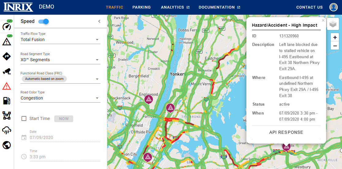
We often rely on INRIX when navigating through congested areas. The app provides a clear map highlighting the most traffic-clogged roads, with the worst delays marked in red, helping you avoid them.
INRIX also allows you to enter your destination and suggests the best route based on real-time traffic conditions.
As the world’s largest driver network, INRIX crowd-sources driving data and updates its system with real-time feedback from drivers. Similar to Google Maps, INRIX displays your route and uses a color-coded traffic light system to indicate traffic levels. What sets INRIX apart is its user-friendly approach to identifying congestion.
For instance, accidents are marked with an overturned car icon, and tapping on it provides details such as the incident’s location, time, and impact on traffic. Like Waze, INRIX personalises routes based on your driving habits and recommends trips and departure times to keep you on schedule.
Waze 
Waze is a favourite among city dwellers, providing real-time updates on routes and traffic conditions through user feedback. The app remembers your frequent routes, destinations, and commute times, optimising your journey based on this information. With Waze, you can plan a drive by entering your desired arrival time, and it will suggest the best time to leave.

Since Google acquired Waze, its functionality has improved, making it a strong contender as a standalone traffic app. Waze relies on community-submitted reports to highlight traffic jams and other road conditions. The 2D map view shows blocked roads, and the route planner helps ensure a smooth journey. Like Google Maps, Waze offers alternative routes when you select a destination, using red lines to show traffic jams and automatically rerouting you when necessary.
However, in its effort to avoid congestion, Waze might sometimes direct you through residential areas, which may not always save time. But if you prefer to keep moving rather than sitting in traffic, Waze is a great choice.
Google Maps
Google Maps is the go-to navigation tool for many, offering straightforward directions with just a few taps. To identify traffic jams along your route, simply zoom out to see red and orange sections indicating delays. Google Maps will estimate how long the delay might be and highlight alternative routes in grey, providing expected journey times for each.
Using real-time data, Google Maps can detect when you’re approaching traffic and suggest a better route. You can review the options and choose the quickest path to avoid delays. One of Google Maps’ standout features is the ability to save your home and work addresses. This allows the app to provide real-time traffic updates for your commute, helping you plan your journey and avoid being late for important appointments.
Whether you are enjoying an open road, or navigating busy city streets, in a brand-new Tusker car, we want you to enjoy the latest entertainment technology and high levels of comfort on every journey.

